Parking Surveys
Service Overview

At The Drone Ranger, we harness cutting-edge drone technology to provide accurate, efficient, and cost-effective parking surveys. Traditional survey methods are often time-consuming, disruptive, and limited in scope, but our aerial solutions deliver real-time insights with unmatched precision. By flying above your site, we capture high-resolution imagery and data that help identify occupancy patterns, traffic flow, and parking utilization with ease.
Our drone surveys are designed to support businesses, planners, and developers in making informed decisions about parking layouts, capacity planning, and site optimization. Whether you’re assessing an existing lot or planning a new development, we give you a clear aerial perspective that eliminates guesswork.
With a focus on safety, compliance, and innovation, The Drone Ranger ensures every survey is carried out to the highest professional standards. We deliver detailed reports and visuals that translate complex data into actionable strategies, helping you maximize efficiency and improve the customer experience.
Our Process
Discover our detailed approach, guiding you through every phase to maximize the value of our traffic survey services.
Planning
Professional drone surveys start with professional planning. Before every flight, we take time to assess, prepare, and secure everything needed for a smooth, safe, and fully compliant operation.
Click to read more…
Safety is at the core of our operations. We conduct thorough risk assessments tailored to each site and project, identifying potential hazards to people, property, and aircraft. This proactive approach helps prevent issues before they arise and ensures every flight meets industry safety standards.
Navigating drone regulations can be complex — but we’ve got it covered. We manage all necessary flight permissions, including coordination with the Civil Aviation Authority (CAA), local air traffic control, and landowners when required. You can trust us to keep your project fully compliant with all legal and airspace regulations.
Every location presents unique challenges, from terrain and weather conditions to nearby structures and restricted zones. We conduct in-depth pre-site analysis using mapping tools, surveys, and local knowledge to optimize flight plans for efficiency and accuracy. This tailored planning ensures we capture exactly what you need — with minimal disruption to your operations.
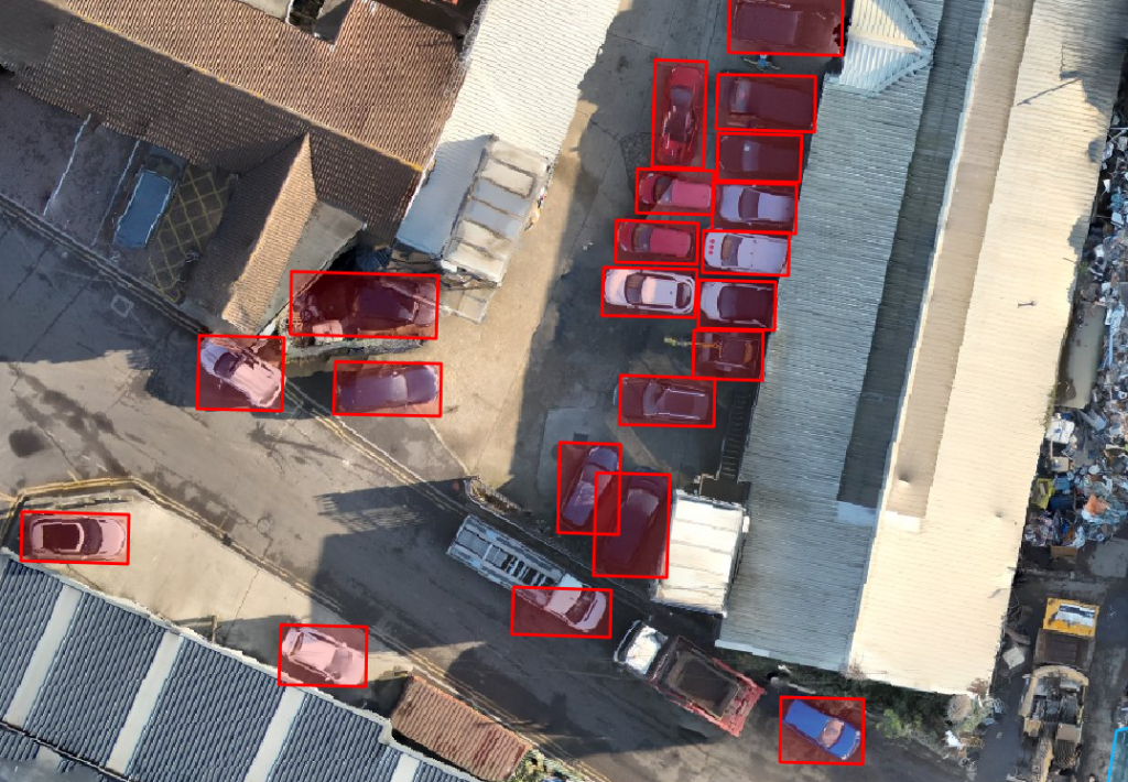
AI Analysis
Harness the power of technology to take your parking surveys to the next level. By using advanced AI software to analyse survey photos, we deliver faster, more accurate vehicle counts—removing the need for manual processing while ensuring reliable results.
Click to read more…
Our process begins with capturing high-quality survey images at regular intervals across the study area. These images are then analysed using AI-based recognition software, which automatically identifies and counts vehicles present on screen. This reduces human error, speeds up processing times, and ensures consistent, objective results.
The software can also distinguish between vehicle types, providing more detailed insights into parking behaviour and demand. Combined with our structured survey methodologies, this approach produces robust datasets that are easy to integrate into reports, modelling, or client presentations.
By embracing AI technology, we not only improve accuracy and efficiency but also create significant time and cost savings. This means you get reliable data faster, with the confidence that every vehicle has been accounted for.
All-Weather Capabilties
Rain or shine, we keep your project on schedule. Our fleet includes cutting-edge drones desgined for performance in tough environments where others might ground or postpone operations.
Click to read more…
Using advanced drones like Matrice M30 feature an IP55 weather resistance rating, meaning it’s built to handle rain, dust, and challenging conditions without compromising safety or data quality. Where standard drones might be grounded, ours keep flying — reducing costly delays for your project. Withstanding winds up to 15 m/s and functioning in temperatures from -20°C to 50°C, the M30 is engineered for resilience. Whether it’s a misty morning, sudden drizzle, or a gusty site, we’re equipped to adapt and continue capturing the data you need.


Lambeth Method Report
Accurate, reliable, and compliant—our parking surveys follow the Lambeth Methodology, the recognised industry standard for data collection and analysis. By adhering to this structured approach, we ensure your survey results are consistent, trustworthy, and ready to inform key decisions.
Click to read more…
The Lambeth Methodology provides a clear framework for recording parking activity, including vehicle counts, occupancy, duration, and turnover within defined survey periods. Our team applies this methodology to deliver results that are not only precise but also directly comparable with other studies, making your data more robust and defensible in planning or policy contexts.
We take care to record observations at consistent intervals, ensuring no detail is missed and that patterns in demand are captured accurately across different times of day. Data is then processed and presented in a clear, structured format—making it easy to review, analyse, and share with stakeholders.
Following the Lambeth Methodology also ensures that our surveys meet local authority expectations, providing you with confidence that the findings will stand up to scrutiny in both technical and public consultation settings. The result is a professional, reliable parking survey you can depend on.