Mapping Surveys
Service Overview
Unlock precise, high-resolution aerial data with our professional drone mapping services. We deliver fast, accurate 2D and 3D maps using cutting-edge UAV technology—perfect for construction, agriculture, real estate, and land surveying. Save time, reduce costs, and make smarter decisions with detailed insights from the sky.
Our licensed drone pilots and mapping specialists use the latest software and sensors to capture topographic data, site progress, volumetric measurements, and more—all with pinpoint accuracy. Whether you’re tracking changes over time or planning your next development, our maps provide the clarity and confidence you need.
Our Process
Discover our detailed approach, guiding you through every phase to maximize the value of our traffic survey services.
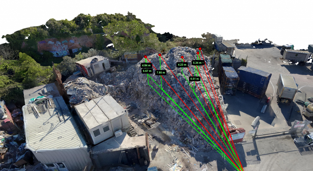
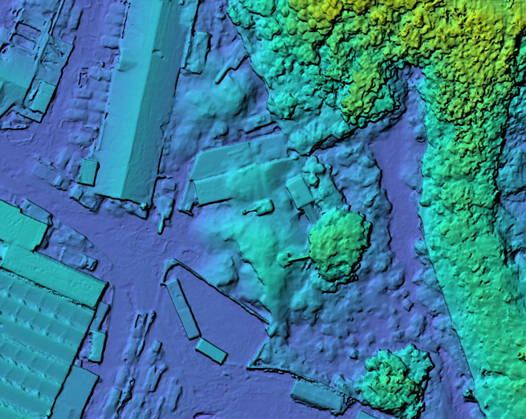
Accurate, high-resolution measurements—such as distances, areas, and volumes—captured quickly and safely from the air to support precise planning and decision-making.
Click to read more…
Our drone mapping service delivers precise measurements of distances, areas, and volumes with unmatched accuracy and speed. By capturing detailed aerial data, we enable you to obtain critical metrics that are essential for project planning, resource management, and progress tracking—all without the need for time-consuming and costly ground surveys.
Whether you’re calculating stockpile volumes, measuring land parcels, or assessing construction site dimensions, our technology provides reliable data you can trust. These measurements help reduce errors, optimize material use, and improve overall efficiency, giving you a clear advantage in managing projects effectively and confidently.
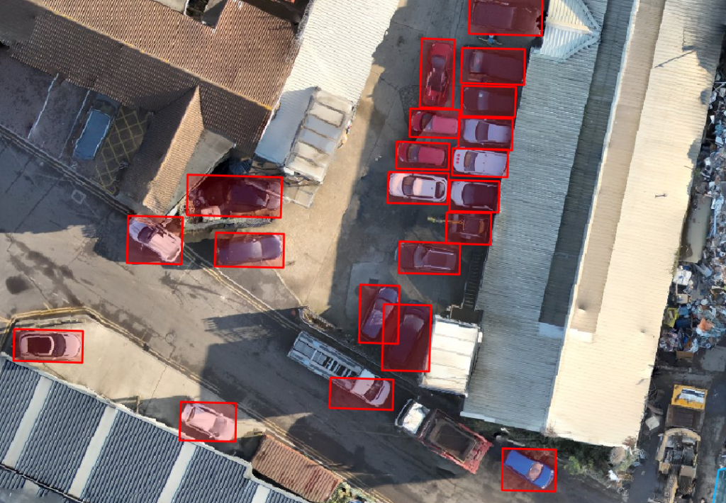
Harness the power of AI-driven object detection to automatically identify and classify cars, boats, planes, and trees with speed and precision.
Click to read more…
Our advanced detection system processes aerial imagery to pinpoint and label objects at scale—eliminating the need for manual review. Whether you’re monitoring traffic, managing coastal assets, analyzing airport environments, or conducting vegetation assessments, our AI delivers consistent, accurate results in a fraction of the time. From urban planning and infrastructure management to environmental surveys and insurance inspections, this technology helps you extract actionable insights from complex imagery. With scalable processing and customizable outputs, our solution adapts to your project—no matter the size or terrain.
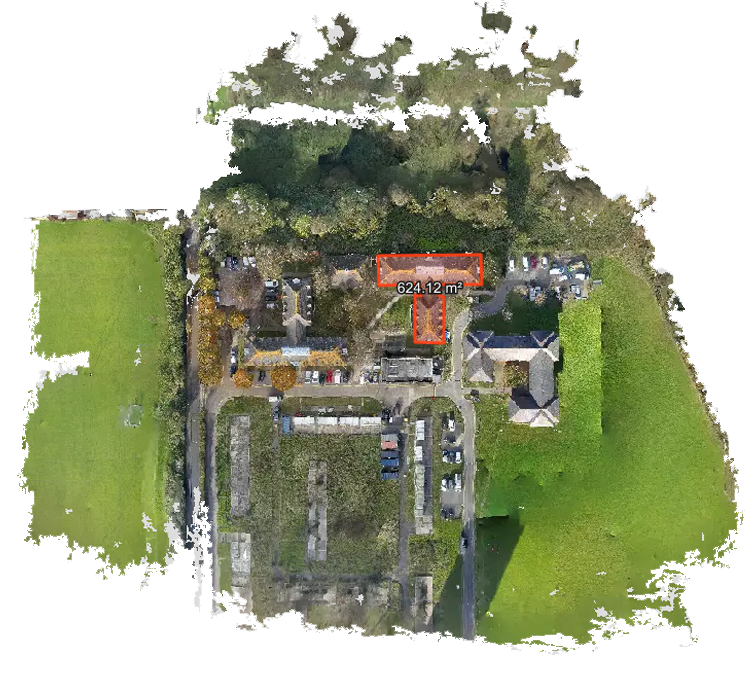
Transform the way you visualize terrain with our high-accuracy contour mapping services—delivering detailed elevation data for smarter planning and design.
Click to read more…
Using drone-captured imagery and advanced photogrammetry, we generate precise contour lines that clearly represent ground elevation changes across any landscape. Ideal for engineering, construction, land development, and flood analysis, our maps provide the topographic clarity needed to make informed decisions from the start. Whether you’re planning earthworks, grading, drainage, or site layouts, our contour maps help reduce guesswork and rework. With fast turnaround times, high-resolution outputs, and seamless CAD/GIS integration, we deliver the data you need—accurate, accessible, and ready to work with.
Quickly and accurately calculate volumes of stockpiles, earthworks, and material movement with our drone-based volumetric survey service. Using high-resolution aerial data and 3D modeling, we deliver precise volume measurements for materials like soil, gravel, sand, and construction debris—without interrupting site operations.
Click to read more…
Our surveys are ideal for mining, construction, and waste management, offering a safer, faster alternative to traditional ground-based methods. Get clear, consistent data you can rely on for project tracking, billing, and resource planning. With frequent flyovers and rapid data processing, you’ll stay informed on material changes over time—empowering smarter decisions and better cost control across every phase of your project.