As cities grow and traffic congestion increases, the need for accurate and efficient traffic surveys has never been greater. Drones have revolutionized various industries with their applications from videography services, search and rescue to solar panel inspections, and off course traffic surveys and the way we collect traffic data; however not all drone operations are created equal. There is a significant difference between professional drone teams—who use weatherproof drones, CAA-qualified professional pilots and obtain the necessary permissions—and unprofessional teams who lack the proper credentials and operate with subpar equipment. Here’s why choosing experienced professionals for drone-based traffic surveys is crucial.
Types of Traffic Surveys and the Role of Drones
Traffic surveys are essential for transportation planning, congestion management, and infrastructure development. Common types of surveys include:
- Vehicle Classification Surveys – Identifying types of vehicles on a road network.
- Journey Time Surveys – Measuring travel times between specific points.
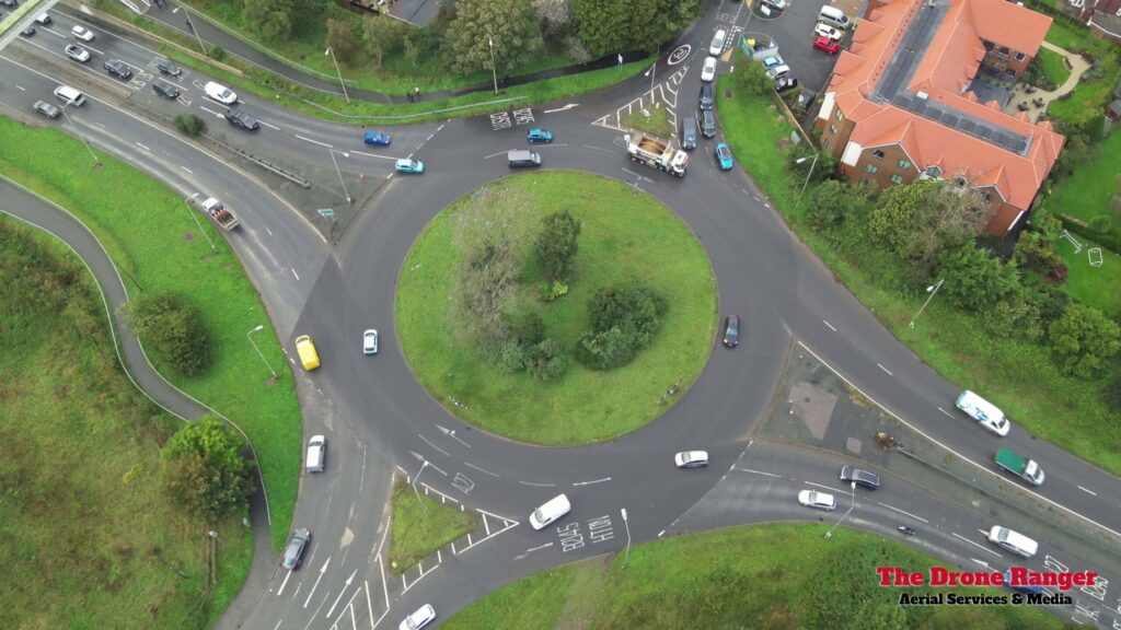
- Turning Movement Counts – Tracking how vehicles navigate intersections.
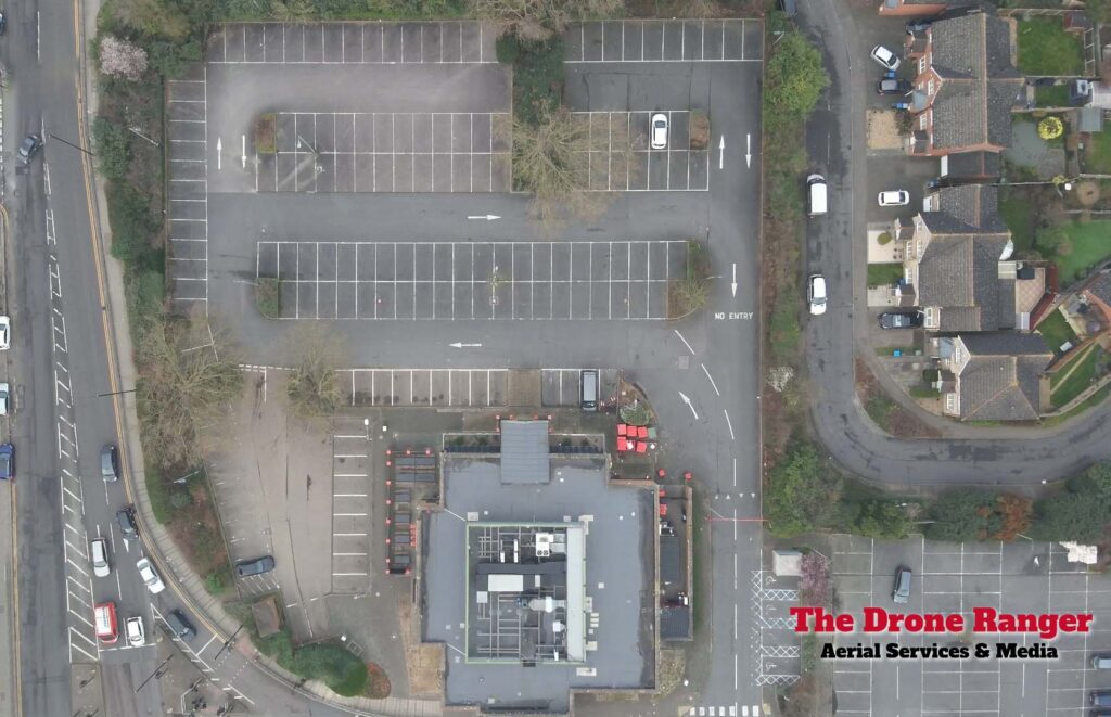
- Parking Occupancy Surveys – Monitoring parking availability and usage.
- Pedestrian and Cyclist Surveys – Understanding foot traffic and non-motorized transport flows.
- Origin-Destination Surveys – Identifying where vehicles are coming from and where they are headed.
- Queue Length Surveys – Measuring the length of vehicle queues at key junctions and intersections.
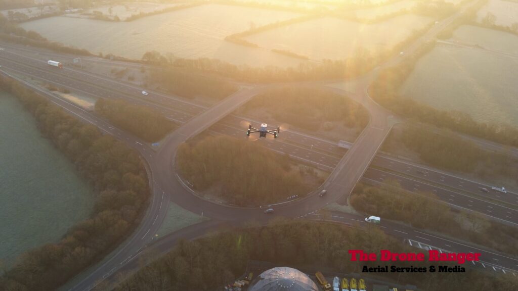
Drones provide a unique advantage by offering a comprehensive aerial view, enabling efficient, large-scale data collection that is difficult for traditional ground-based methods to match. The ability to cover large areas quickly, showcasing queue lengths, points of congestion and the entire scope from an aerial view makes drones particularly useful for complex urban environments and high-traffic locations.
Regulatory Compliance and Legal Assurance
Professional drone operators are certified by the Civil Aviation Authority (CAA) and follow strict regulatory guidelines. They secure the necessary flight permissions and ensure full compliance with airspace laws. This is particularly important in urban settings where restricted airspace can pose significant challenges. In contrast, unqualified teams often ignore these requirements, increasing the risk of legal issues, fines, and potential project shutdowns.
Reliable and Weatherproof Equipment
Professional teams use advanced, weatherproof drones like the DJI M30 or M300, designed to operate in harsh conditions, including rain and strong winds. These UAVs ensure uninterrupted data collection regardless of weather challenges. Amateur teams, on the other hand, often rely on consumer-grade drones that are vulnerable to rain, wind, and extreme temperatures, leading to unreliable results and failed surveys. A weatherproof drone ensures that surveys can continue uninterrupted, preventing costly delays. Drones like the M30 and M300 also feature intelligent batteries and charging units, making it easier to recharge and be used again & again on the same survey, consumer-grade drones often don’t feature this and be restricted in the how long they can conduct a survey.
Accurate and High-Quality Data Collection
Certified professionals operate high-performance drones equipped with advanced sensors, AI-powered analytics, and high-resolution cameras to capture precise traffic data. Their expertise ensures accurate vehicle counting, movement tracking, and congestion analysis. This accuracy is essential for making informed decisions about infrastructure planning, road safety improvements, and traffic signal optimization. Unskilled operators may use low-quality drones with limited capabilities, leading to errors and incomplete data that can compromise traffic planning decisions.
The Lambeth Methodology: Standardizing Traffic Surveys
One of the widely accepted frameworks for traffic data collection is the Lambeth Methodology. This methodology emphasizes consistency, accuracy, and repeatability in traffic surveys, ensuring that data is collected in a standardized manner for effective comparison and analysis. Professional drone operators trained in this methodology ensure that the data gathered aligns with industry standards, making it more valuable for traffic planners and urban developers. Following a recognized methodology enhances the credibility and usefulness of traffic data.
Safety and Risk Mitigation
Conducting traffic surveys with drones involves operating near roads and populated areas, requiring careful risk assessment and flight planning. Professional teams follow strict safety protocols to prevent accidents and ensure public safety. They conduct pre-flight risk assessments, adhere to no-fly zones, and have contingency plans for emergencies. Unlicensed operators often lack proper training, increasing the risk of drone malfunctions, crashes, and potential liabilities. Additionally, the use of redundancies such as dual battery systems ensures safe operations.
Efficient and Non-Disruptive Operations
Experienced drone operators conduct surveys seamlessly without disrupting traffic flow. They plan flight paths strategically to maximize coverage while minimizing interference. Using drones eliminates the need for manual traffic counting or placing sensors on roads, which can cause disruptions and safety concerns. Unqualified teams may struggle with coordination, leading to inefficient surveys that waste time and resources.
Comprehensive Reporting and Data Analysis
Beyond just collecting raw footage, professional drone teams provide comprehensive reports with actionable insights. Their expertise in data analysis ensures meaningful conclusions that support urban planning and traffic management. Using AI-powered software, they can automatically detect congestion patterns, track vehicle speeds, and analyze peak-hour traffic behavior. This level of detail is invaluable for traffic engineers and city planners. Amateur operators may lack the technical knowledge to interpret data correctly, rendering their results ineffective.
Environmental and Sustainability Benefits
Drone-based traffic surveys offer a more sustainable alternative to traditional methods. Ground-based surveys often involve deploying multiple vehicles and personnel, leading to increased fuel consumption and emissions. Drones, on the other hand, have a much smaller carbon footprint and can conduct surveys without contributing to congestion or pollution. Additionally, the efficiency of drones means fewer resources are required to collect the same amount of data.
Scalability for Large-Scale Studies
For large-scale traffic studies spanning multiple areas, drones provide a scalable solution. By deploying multiple drones simultaneously, operators can collect data across different locations in real-time, making regional traffic planning more efficient. This is particularly useful for large infrastructure projects, transport policy development, and emergency response planning.
Conclusion
Drones are transforming the traffic survey industry by making data collection faster, safer, and more accurate. However, the quality of these surveys depends on the expertise and professionalism of the drone operators. Choosing professional drone operators ensures reliable, accurate, and legally compliant data collection. With CAA-certified pilots, weatherproof drones like the DJI M30, and expertise in risk management, professionals provide superior results that support effective traffic planning.
Additionally, adherence to recognized methodologies such as the Lambeth Methodology ensures standardized and actionable insights. The environmental benefits, scalability, and data accuracy provided by professional drone operations make them the optimal choice for modern traffic management solutions. In contrast, hiring unqualified teams can lead to unreliable data, legal issues, and potential safety hazards.
If you want precise and legally compliant traffic surveys conducted by industry experts, contact us today to learn more about our professional drone solutions!
Share This Story, Choose Your Platform!
About the Author: gail.simmons@thedrone-ranger.co.uk
